


JERUSALEM 2 Voting District, Lucas County, Ohio
About
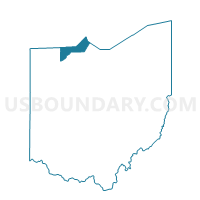
Outline

Summary
| Unique Area Identifier | 649068 |
| Name | JERUSALEM 2 Voting District |
| County | Lucas County |
| State | Ohio |
| Area (square miles) | 12.46 |
| Land Area (square miles) | 11.39 |
| Water Area (square miles) | 1.06 |
| % of Land Area | 91.47 |
| % of Water Area | 8.53 |
| Latitude of the Internal Point | 41.63469130 |
| Longtitude of the Internal Point | -83.29025840 |
Maps


Graphs
Select a template below for downloading or customizing gragh for JERUSALEM 2 Voting District, Lucas County, Ohio


Neighbors
Neighoring Voting District (by Name) Neighboring Voting District on the Map
- 011 ALLEN 3, Ottawa County, OH
- 016 BENTON 3, Ottawa County, OH
- 018 CARROLL 2, Ottawa County, OH
- JERUSALEM 1 Voting District, Lucas County, OH
- JERUSALEM 3 Voting District, Lucas County, OH
- WATER, Ottawa County, OH
- Water, Lucas County, OH
Top 10 Neighboring County Subdivision (by Population) Neighboring County Subdivision on the Map
- Allen township, Ottawa County, OH (3,780)
- Jerusalem township, Lucas County, OH (3,109)
- Benton township, Ottawa County, OH (2,641)
- Carroll township, Ottawa County, OH (2,135)
Top 10 Neighboring Unified School District (by Population) Neighboring Unified School District on the Map
- Oregon City School District, OH (23,523)
- Benton-Carroll-Salem Local School District, OH (10,225)
- Genoa Area Local School District, OH (8,695)
- School District Not Defined (Water), OH (4)
Top 10 Neighboring State Legislative District Lower Chamber (by Population) Neighboring State Legislative District Lower Chamber on the Map
Top 10 Neighboring State Legislative District Upper Chamber (by Population) Neighboring State Legislative District Upper Chamber on the Map
Top 10 Neighboring 111th Congressional District (by Population) Neighboring 111th Congressional District on the Map
Top 10 Neighboring Census Tract (by Population) Neighboring Census Tract on the Map
- Census Tract 509, Ottawa County, OH (5,659)
- Census Tract 508, Ottawa County, OH (4,056)
- Census Tract 511, Ottawa County, OH (3,780)
- Census Tract 97, Lucas County, OH (3,100)